
Church History · Early Church · Historical Background
GEOGRAPHY OF THE HOLY LAND
A Reader’s Guide to Judea, Galilee, Samaria, Jerusalem, and the Jordan Valley
Geography and Sources Library
Start Here
The Holy Land is not merely the background of the Bible. Its mountains, valleys, deserts, rivers, roads, and towns shaped the history of Israel, the ministry of Jesus Christ, and the first movement of the Gospel.
Geography explains why Jerusalem became the center of pilgrimage and Temple worship, why Galilee supported fishing and village life, why Samaria stood between Judea and Galilee, and why the road from Jerusalem to Jericho became a vivid setting for Christ’s parable of the Good Samaritan.
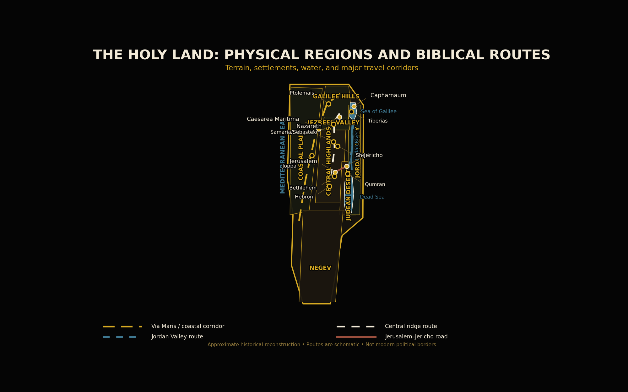
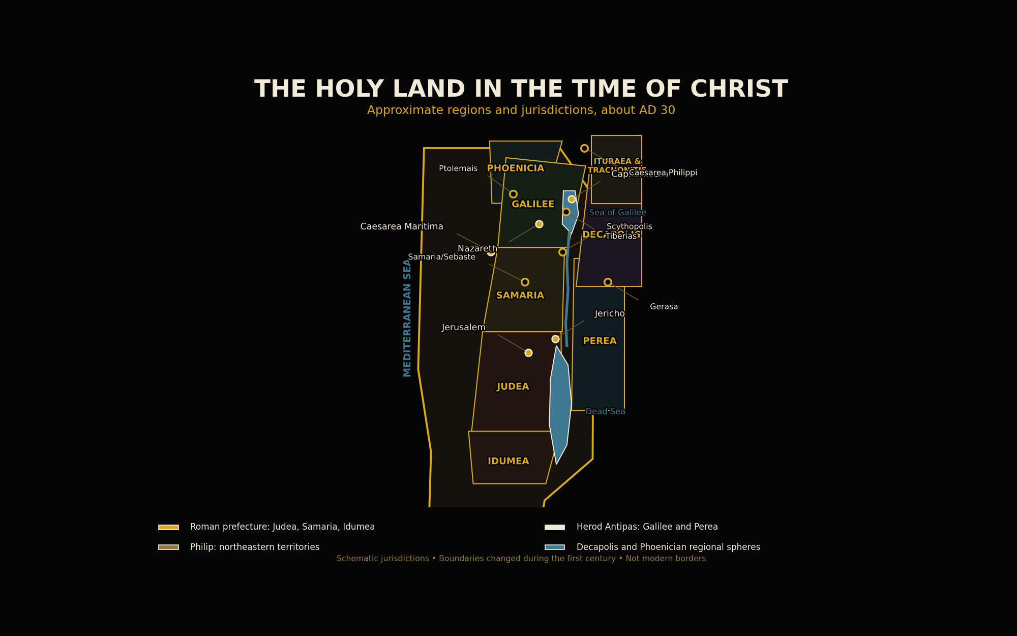
The two maps on this page answer different questions. The first shows physical geography and movement. The second shows regions and jurisdictions about AD 30. Neither map uses modern political borders.
How to Read These Maps
The maps deliberately separate information that is often crowded together. City names are placed outside the narrow central landmass and connected to their locations with leader lines. This keeps labels from covering rivers, roads, regional names, or one another.
The first map uses color to distinguish physical zones and line styles to distinguish routes. It does not claim that ancient roads followed one perfectly surveyed line. The second map uses broad color fields to show approximate jurisdictions about AD 30. These were administrative and cultural regions, not modern national borders.
Large regional labels identify the area being discussed; dots identify specific settlements. The maps emphasize the places most useful for reading the Gospels and Acts rather than attempting to include every ancient village or road.
Map One: Land, Water, Cities, and Routes
The Land at a Glance
The Coast
The Mediterranean coastal plain encouraged trade, military movement, ports, and contact with the wider world.
The Highlands
Galilee, Samaria, and Judea were shaped by hill country, ridges, valleys, villages, and defensible cities.
The Jordan Rift
The Sea of Galilee, Jordan River, Jordan Valley, and Dead Sea form the great eastern depression of the land.
The Wilderness
The Judean Desert and southern drylands shaped travel, retreat, testing, monastic memory, and biblical imagery.
The Coastal Plain and Central Ridge
The Mediterranean coast provided the easiest north–south corridor through much of the land. Ports such as Caesarea Maritima and Joppa linked the region with Egypt, Asia Minor, Greece, Italy, and the wider Roman Mediterranean.
East of the coastal plain, the land rises into the central highlands. A ridge route connected Hebron, Bethlehem, Jerusalem, Shechem, Samaria, and locations farther north. This route passed through country very different from the level coast.
The contrast between coast and highlands mattered politically. Armies and commerce often favored broad corridors, while upland towns could be easier to defend. The central ridge also preserved strong local identities and contained many places central to Israel’s covenant history.
Galilee
Galilee was the principal setting of Jesus’ public ministry before the final journey to Jerusalem. Nazareth, Cana, Capharnaum, Magdala, Bethsaida, Tiberias, and the Sea of Galilee belong to this northern world.
The region combined hills, fertile valleys, villages, fishing settlements, and access to major routes. It was rural without being isolated. Nearby cities and roads connected Galilee with the Decapolis, Phoenicia, Syria, and the wider Greco-Roman world.
The Sea of Galilee supported fishing, transport, and lakeside settlement. The calling of fishermen, the calming of the storm, the multiplication of loaves, and several Resurrection appearances are inseparable from this landscape.
The Jezreel Valley southwest of Galilee formed an important corridor between the coast and inland routes. Megiddo and surrounding passes had long possessed military importance.
Samaria
Samaria lay between Galilee and Judea. It was both a geographic region and the homeland of a community whose worship and identity were related to ancient Israel yet distinct from Judean Judaism.
Travelers moving between Galilee and Jerusalem could pass through Samaria or take a longer route through the Jordan Valley and Perea. This geographic fact gives context to the Gospel of St. John’s account of Jesus and the Samaritan woman.
The parable of the Good Samaritan depends upon real religious and social tension. Christ deliberately made the compassionate Samaritan the neighbor who fulfilled the command of mercy.
Acts later presents Samaria as one of the first regions beyond Jerusalem to receive apostolic preaching, fulfilling the movement announced in Acts 1:8.
Judea and Jerusalem
Judea was the southern center of Jewish religious life. Jerusalem, Bethlehem, Bethany, Jericho, Hebron, and the Judean wilderness shaped the infancy narratives, public ministry, Passion, Resurrection, and earliest chapters of Acts.
Jerusalem stood in the hill country rather than on the coast or a great river. Its importance came above all from covenant history, Davidic kingship, the Temple, pilgrimage, and the worship of the God of Israel.
The city’s elevation and surrounding valleys affected defense and travel. Pilgrims ascended toward Jerusalem, and the Psalms of Ascents gave spiritual language to that movement.
The Gospel narratives move toward Jerusalem because salvation history moves there. Christ teaches in the Temple, celebrates the Last Supper, suffers under Pontius Pilate, dies outside the city, rises from the dead, and commands that the Church’s witness begin from Jerusalem.
The Jordan Valley, Dead Sea, and Wilderness
The Jordan River flows south from the Sea of Galilee toward the Dead Sea. It recalls Israel’s entry into the promised land and the ministries of Elias and Eliseus.
St. John the Baptist preached and baptized in the Jordan region. Jesus entered the waters, not because He required repentance, but to identify Himself with sinners and begin His public manifestation.
The Jordan Valley also formed a practical travel corridor. Jericho stood near routes connecting Jerusalem, the valley, Perea, and northern regions.
West of the Dead Sea lies harsh wilderness. The Judean Desert evokes testing, solitude, repentance, and dependence upon God. The Dead Sea Scrolls were discovered in this broader region and illuminate Jewish Scripture, community life, and expectation near the time of Christ.
Map Two: The Holy Land About AD 30
Political Geography in the Time of Christ
The Holy Land did not form one simple political unit during Jesus’ ministry. Roman supremacy stood above several local arrangements.
Judea, Samaria, and Idumea were governed through the Roman prefecture associated with Pontius Pilate. Galilee and Perea were ruled by Herod Antipas. Northeastern territories were governed by Philip the tetrarch. The Decapolis consisted of Greek cities and their surrounding spheres, while the Phoenician coast belonged within Roman Syria.
These jurisdictions changed during the first century, so the map represents an approximate setting about AD 30 rather than a permanent border system.
This political geography clarifies why the Gospels mention Caesar, Pilate, Herod Antipas, Philip, the high priesthood, tax collectors, soldiers, and city authorities within the same historical world.
Roads and Movement
The most important routes followed terrain. The Via Maris connected Egypt, the coastal plain, the Jezreel Valley, Galilee, and Syria. A central ridge route joined the highland towns. The Jordan Valley route provided another north–south corridor.
The road from Jerusalem to Jericho descended steeply from the highlands toward the valley. Its exposed and difficult character made it an effective setting for the Good Samaritan.
Ancient travel depended upon walking, animals, weather, water, hospitality, security, and the condition of roads. A short distance on a modern map might require a demanding journey through elevation and heat.
Jesus’ movements through Galilee, Samaria, Judea, the Jordan region, Phoenician territory, and the Decapolis reveal a ministry that crossed social and regional boundaries without becoming detached from Israel.
Geography and the Gospels
- Nazareth places the hidden life of Jesus within an ordinary Galilean town.
- Capharnaum became an important center of teaching, healing, and discipleship.
- The Sea of Galilee explains the presence of fishermen, boats, storms, and lakeside crowds.
- Caesarea Philippi forms the northern setting of St. Peter’s confession.
- Samaria gives historical depth to Christ’s encounters with Samaritans.
- Jericho stood near the ascent to Jerusalem and appears in healing, conversion, and parable.
- Jerusalem unites Temple worship, the Passion, Resurrection, Pentecost, and apostolic mission.
A Theological Geography
Scripture never treats land as meaningless. Creation, covenant, exile, return, pilgrimage, Temple, wilderness, city, mountain, river, and road all carry theological meaning because God acts through real history.
Places do not become myths merely because they also function as signs. Jerusalem is a real city and also points toward the heavenly Jerusalem. The wilderness is a real environment and also becomes a place of testing and purification.
The Holy Land is therefore both a historical setting and a theological sign within salvation history. Its holiness comes from God’s saving action, culminating in the Incarnation, Passion, Death, and Resurrection of Jesus Christ.
Common Mistakes to Avoid
- Do not treat Judea, Galilee, and Samaria as interchangeable.
- Do not read modern political borders into the first century.
- Do not imagine Galilee as isolated from trade and Greco-Roman influence.
- Do not assume every ancient route followed a modern highway.
- Do not treat the Decapolis as a single Jewish province.
- Do not reduce biblical places to symbols without historical reality.
- Do not make approximate regional boundaries appear more certain than the evidence allows.
Key Takeaways
- The Holy Land contains sharply different physical regions within a small area.
- Terrain shaped agriculture, settlement, defense, travel, and public ministry.
- Galilee formed the main setting of Jesus’ early public ministry.
- Samaria stood geographically and religiously between Galilee and Judea.
- Jerusalem and the Temple remained the center of Jewish pilgrimage and worship.
- The Jordan Valley and wilderness carry both practical and theological importance.
- First-century jurisdictions explain the presence of Roman, Herodian, priestly, and civic authorities.
- Clear geography makes the Gospels easier to understand without replacing theological interpretation.
Continue Your Study
Sources and Further Reading
- Holy Bible, Douay-Rheims: Josue 3–6; Third Kings 18; Fourth Kings 2; Psalms 120–133; Matthew 2–5, 8–9, 13–17, and 21–28; Mark 1–16; Luke 1–24; John 1–21; Acts 1–10.
- Catechism of the Catholic Church, 535–560, 583–586, and 1093–1095.
- Flavius Josephus, The Jewish War, Books I–II.
- Flavius Josephus, Jewish Antiquities, Books XVII–XVIII.
- Eusebius of Caesarea, Onomasticon.
- Jerome Murphy-O’Connor, The Holy Land: An Oxford Archaeological Guide.
- Jodi Magness, The Archaeology of the Holy Land: From the Destruction of Solomon’s Temple to the Muslim Conquest.
- Michael Avi-Yonah, The Holy Land from the Persian to the Arab Conquests: A Historical Geography.
- Anson F. Rainey and R. Steven Notley, The Sacred Bridge: Carta’s Atlas of the Biblical World.