
Church History · Early Church · Historical Background
GEOGRAPHY OF THE ROMAN WORLD
The Mediterranean, Roman Provinces, Apostolic Centers, Roads, Ports, and Sea Lanes
Geography and Sources Library
Start Here
The Church began in Jerusalem and entered a Mediterranean world governed by Rome. Provinces, ports, cities, roads, sea lanes, Jewish communities, and common languages formed the historical setting in which the Apostles preached Christ.
These networks did not cause conversion. The Holy Ghost, apostolic testimony, sacramental life, charity, and fidelity to Christ explain the Church’s mission. Roman connectivity supplied practical channels through which missionaries, letters, prisoners, merchants, and households moved.
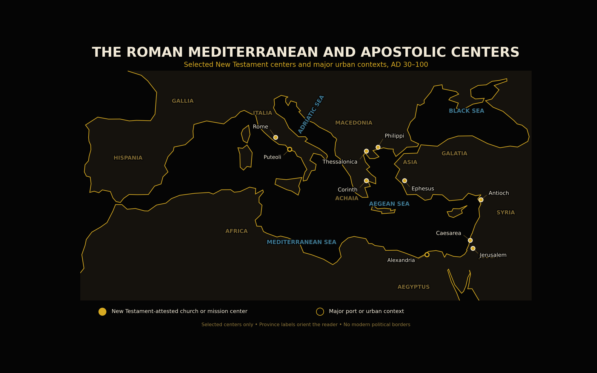
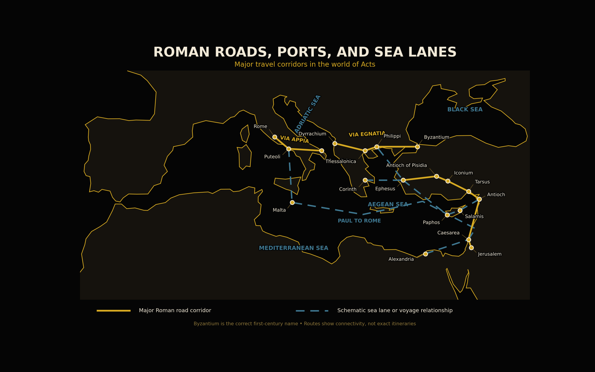
The first map identifies selected apostolic centers. The second shows the roads, ports, and sea relationships most useful for understanding Acts and the Pauline mission.
How to Read the Maps
Black Background
The public map contains no research dashboard, production sidebar, or modern political coloring.
Gold Markers
Filled gold markers identify selected New Testament-attested churches or mission centers.
Hollow Markers
Hollow markers identify major ports or urban contexts without claiming equal first-century Christian documentation.
Gold and Blue Routes
Gold shows major road corridors; muted blue shows schematic sea lanes and voyage relationships.
Map One: The Roman Mediterranean and Apostolic Centers
The Mediterranean World
The Mediterranean Sea connected the Roman world. Coastal shipping moved grain, oil, wine, troops, officials, letters, pilgrims, prisoners, merchants, and travelers over long distances.
Sea travel was neither simple nor safe. Winds, winter conditions, ship availability, war, commercial schedules, and the danger of shipwreck all affected movement. Acts 27–28 preserves one of antiquity’s most vivid accounts of a difficult voyage.
Ports connected cities with inland regions. Puteoli served traffic entering Italy. Caesarea Maritima linked Judea with imperial administration and Mediterranean travel. Ephesus, Corinth’s harbors, and Antioch’s port at Seleucia connected major urban centers with wider networks.
Provinces and Regional Difference
The Roman Empire was divided into provinces whose histories, languages, laws, and civic traditions differed. Italy, Achaia, Macedonia, Asia, Galatia, Cilicia, Syria, Judea, and Egypt did not form one uniform culture.
Rome often governed through existing cities, local elites, tax systems, councils, client rulers, and provincial officials. Boundaries and administrative status could change, so province labels on a reader map should orient rather than pretend to exact permanence.
The eastern Mediterranean remained strongly Greek-speaking, while Latin held greater importance in Roman administration, the army, law, Italy, and the western provinces.
Cities and the Apostolic Mission
The apostolic mission became especially visible in cities because cities gathered synagogues, marketplaces, courts, workshops, households, travelers, officials, and regional roads.
Jerusalem was the beginning of the visible mission. Antioch became a major center from which Sts. Paul and Barnabas were sent. Ephesus linked the Aegean coast with Roman Asia. Corinth stood near two harbors. Philippi and Thessalonica were connected with the Via Egnatia. Rome stood at the political center of the empire.
Urban churches were not isolated from rural populations. Households, coworkers, trade, hospitality, and correspondence allowed the Gospel to move outward from one community to another.
Jerusalem, Antioch, and Rome
Acts begins in Jerusalem, moves through Judea and Samaria, and follows the Gospel toward the nations. Antioch joins the biblical homeland with Syria, Asia Minor, and the wider Mediterranean.
Rome already contained Christians before St. Paul arrived. His Epistle to the Romans addresses an existing church, and Acts ends with Paul proclaiming the kingdom of God in the imperial capital.
This geographic movement does not make Rome the source of the Gospel. It shows the apostolic message moving from Jerusalem toward the nations and entering the center of imperial power.
Diaspora Judaism
Jewish communities lived throughout many Roman cities. Synagogues gathered Scripture, prayer, charity, and communal life. Gentiles who respected Israel’s God also encountered Jewish teaching.
St. Paul often began in synagogues because they offered hearers formed by the Law and the Prophets. When opposition arose, he continued preaching to Gentiles without denying Israel’s place in salvation history.
Pentecost itself reflects this diaspora geography: Jews from many lands were present in Jerusalem and heard the Apostles proclaim the mighty works of God.
Households, Letters, and Local Networks
The geography of the early Church was not limited to roads and public buildings. Christian communities often gathered in households, and those households linked relatives, patrons, servants, travelers, artisans, and coworkers.
Letters moved through trusted messengers rather than an impersonal modern postal service. A letter could introduce a delegate, settle a dispute, encourage a church, request hospitality, or preserve teaching across distance. The Pauline epistles reveal these personal networks through greetings, names, journeys, and requests for cooperation.
Women and men who opened their homes, supported missionaries, carried letters, and assisted local churches helped turn geographic routes into living bonds of communion. The map shows cities; the history also depends upon persons.
Map Two: Roads, Ports, and Sea Lanes
Roman Roads
Roman roads were built primarily for military movement, administration, and imperial communication. Civilians, merchants, pilgrims, prisoners, and missionaries also used them.
The Via Appia linked Rome with southern Italy. The Via Egnatia crossed Macedonia from the Adriatic toward Byzantium. Roads through Asia Minor connected Ephesus with inland colonies, Cilicia, and Syria.
Major highways were only part of the system. Local roads, mountain tracks, urban streets, ferries, and private hospitality remained necessary. Travel involved fatigue, cost, weather, animals, security, and the possibility of robbery.
Ports and Sea Travel
Ancient travelers often used commercial vessels rather than dedicated passenger ships. They shared space with cargo, sailors, soldiers, officials, prisoners, and other travelers.
Sea lanes were not fixed modern shipping routes. A ship’s path depended upon winds, season, cargo, destination, available harbors, and the captain’s judgment.
The voyage of St. Paul toward Rome illustrates these conditions. He changed ships, encountered contrary winds, suffered shipwreck on Malta, and finally traveled through Puteoli toward Rome.
Byzantium, Not Constantinople
The first-century city at the Bosporus was Byzantium. The name Constantinople belongs to the fourth century, after Constantine established the city as an imperial capital.
The map therefore uses Byzantium. This avoids projecting later imperial and ecclesiastical geography backward into the apostolic age.
Why Roman Geography Matters for Reading Acts
Geographic knowledge clarifies the sequence of Acts. Jerusalem belongs to the Jewish and biblical homeland. Antioch becomes a missionary center. Cyprus, Asia Minor, Macedonia, Achaia, and Rome form successive fields of apostolic movement.
Distance also explains why conflicts, decisions, and reports required messengers and travel. The Council of Jerusalem was not a quick local meeting for every Christian community; its judgment had to be carried outward and received by churches in other regions.
Geography likewise guards against reading Acts as a collection of disconnected stories. The book follows the Gospel’s movement through identifiable cities, provinces, roads, ports, and political jurisdictions. This historical structure strengthens rather than weakens the theological meaning of the narrative.
Imperial Order and Imperial Violence
Roman institutions could provide roads, courts, legal procedures, and public order. St. Paul sometimes appealed to his Roman citizenship and received protection from unlawful treatment.
The same empire practiced conquest, slavery, military suppression, crucifixion, and religious coercion. Jesus Christ was crucified under Pontius Pilate.
Historical judgment should neither romanticize Rome nor deny the practical goods of order and communication. Providence can use imperfect institutions without approving their sins.
From Geography to Ecclesial Communion
As churches endured, geography shaped correspondence, assistance, travel, episcopal oversight, and regional relationships. Christian communities exchanged letters, received visitors, supported the poor, and maintained communion across distance.
Important sees often arose in cities already significant for government, trade, or apostolic memory. Their ecclesial importance, however, cannot be reduced to economics or imperial administration.
The Roman world supplied roads and cities. Christ supplied the Church’s faith, unity, sacraments, and mission.
Distance and Time
Modern maps compress distance into a glance. Ancient travelers experienced distance through days of walking, changes of ship, steep terrain, weather, expense, illness, and the need to find lodging. A route that appears simple on a page could involve weeks or months of uncertainty.
This helps explain the importance of coworkers and local churches. Mission did not depend upon one Apostle appearing everywhere at once. St. Paul sent trusted companions, received reports, wrote letters, returned to communities, and relied upon believers who remained in place.
Geography therefore reveals both the difficulty of apostolic labor and the remarkable unity of communities spread across the Roman world.
Common Mistakes to Avoid
- Do not reduce the Roman world to the city of Rome.
- Do not read modern national borders into ancient provinces.
- Do not treat every city as equally documented in the same decade.
- Do not call first-century Byzantium “Constantinople.”
- Do not treat road and sea lines as exact itineraries.
- Do not imagine Roman travel as easy or safe.
- Do not claim infrastructure caused conversion or the Church.
- Do not ignore the importance of diaspora Judaism.
Key Takeaways
- The Mediterranean connected the Roman provinces and their cities.
- The apostolic mission moved through urban, Jewish, household, commercial, and legal networks.
- Jerusalem, Antioch, Ephesus, Corinth, Macedonia, and Rome played different historical roles.
- Roads and ports facilitated travel without removing danger or hardship.
- Greek predominated in much of the East, while Latin grew in importance in the West.
- Roman order existed beside conquest, slavery, crucifixion, and persecution.
- Byzantium is the correct first-century name for the city later called Constantinople.
- Geographic networks became channels of ecclesial communion, not the source of the Gospel.
Continue Your Study
Sources and Further Reading
- Holy Bible, Douay-Rheims: Luke 2; Acts 2, 9–28; Romans 15–16; First Corinthians 1–16; Second Corinthians 11; Philippians; Apocalypse 1–3.
- Catechism of the Catholic Church, 830–856 and 1897–1927.
- Flavius Josephus, The Jewish War and Jewish Antiquities.
- Strabo, Geography.
- Pliny the Elder, Natural History.
- Richard J. A. Talbert, ed., Barrington Atlas of the Greek and Roman World.
- Fergus Millar, The Roman Near East, 31 BC–AD 337.
- Lionel Casson, Travel in the Ancient World.
- Colin Adams and Ray Laurence, eds., Travel and Geography in the Roman Empire.
- Wayne A. Meeks, The First Urban Christians.